
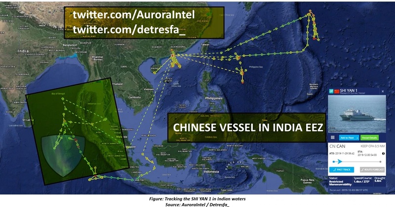
Comprehensive mapping of the Indian Ocean Region by Chinese ships in the handle of study adjacent to the Indian oceans could be handled by naval administrators, an inquiry by Open-Source Intelligence (OSINT) experts tracing the action of these vessels over the last two years reveals. Thorough monitoring of maritime traffic movements in the Indian Ocean Region by OSINT experts like H.I. Sutton (@CovertShores), @detresfa_, and @AuroraIntel reveals how the information is collected in the name of study for nonmilitary goals could also be essential for military usage.
Some of these survey vessels were also located near to Andaman and Nicobar Islands. Naval expert Sutton and Naval News have given exclusive aspects of the actions of these research ships in the Indian Ocean Region. A Chinese survey ship, the Xiang Yang Hong 03, before moving in the Indian Ocean is presently in the South China Sea. The ship is purportedly conducting out a host of procedures that involve the mapping of the seabed and documentation of various other parameters and metrics including the area.
This ship made a debate last week for its skeptical actions when it was cited as ‘running dark’, without proclaiming its location in Indonesian territorial waters. Indonesia’s Maritime Security Agency (Baklama) caught this Chinese research and survey ship sailing without an Automatic Identification System (AIS) in the strategic Sunda Strait. The occurrence comes shortly after the detection of a presumed Chinese survey drone in the nearby Makassar Strait, widely covered by India Today earlier. Ultimately, the Indonesian patrol vessel accompanied the Xiang Yang Hong from the Indonesian Exclusive Economic Zone (EEZ). All these fragmented events must be examined collectively as a significant attempt by China to systematically draft the seabed across the broad zone of the Indian Ocean.
A study of exclusive ship tracking data from MarineTraffic reveals that it is not the first time the vessel has this area. The ship Xiang Yang Hong 03, in special, is a frequent visitor in Indonesian and the Indian Ocean based on a report by The Intel Lab, using AIS data. The extrapolation of data analysis reveals that these study ships may not just be carrying civilian research but could also collecting data for naval planners. The eastern Indian Ocean is expected to be of special attention to the Chinese Navy as they develop their submarine skills. The data from these surveys may help submarines operate or increase their possibilities of surviving undetected.OSINT investigators have been tracing Chinese government survey ships for some time soon. Now a more distinct pattern is developing, especially in the Indian Ocean. Four of China’s Xiang Yang Hong (‘Facing the Red Sun’) research ships have been especially busy in this area over the past two years. These ships are:
Xiang Yang Hong 01
Xiang Yang Hong 03
Xiang Yang Hong 06
Xiang Yang Hong 19
They are moved by China’s State Oceanic Administration (SOA). These vessels are all comparatively new, having been created in the last decade. This highlights the point that China is putting on its survey ship fleet. Two of these ships, the Xiang Yang Hong-01 and Xiang Yang Hong-16, have been carrying large surveying over the Ninetyeast Ridge, an underwater mountain range with channels over the Indian Ocean. Their disciplined racetrack designs are characteristic of mapping the seabed. For this, they would pull high-resolution side-scan sonar. Among them, these ships have done multiple tours with each opening where the other ended.
The idea for concentrating on the Ninetyeast Ridge is unconfirmed, but it may be especially vital for submarine operations. It forms an almost continuous extent of shallow water over the ocean where submarines may be subject to detection. Some of the survey projects, adjacent to Indonesia and the Andaman and Nicobar Islands, may link to getting the US Navy’s reputed ‘fish-hook’ sensor channels. These are intended to trace Chinese submarines accessing the Indian Ocean. This is not the first time Chinese ships have entered the Indian oceans to bring out surveying exercises.
The gliders used were Sea Wing (Haiyi) model. This is the identical type that has been setting up in the Indonesian oceans. This increases the chance that as strongly as the Xiang Yang Hong 06, other Chinese ships may be using the gliders. It is challenging to learn the shipping point for the gliders located in Indonesian waters. But it is not a great leap to propose that China has used more in the Eastern Indian Ocean. The Xiang Yang Hong 03’s current tour will be observed closely. Defense analysts have now been concentrating on China’s increasing survey ship fleet, watching for signs to planned skills and strategies.
Post Your Comments