In international politics, there are many types of aggression, and some are driven by water. After officially annexing Tibet in 1951 and making it part of the People’s Republic, China gained control over major river systems and became the dominant power in control of Asia’s water map. Due to that annexation, China today sits upriver of major water sources in South and South East Asia, making its southern neighbors, including India, nervous whenever Beijing plans to build a dam on any river rising in the Tibetan highlands. The rivers Indus, Ganga, Brahmaputra, Irrawaddy, Salween, Yangtze and Mekong, which flow into Pakistan, India, Bangladesh, Myanmar, Laos and Vietnam, all originate in Tibet.
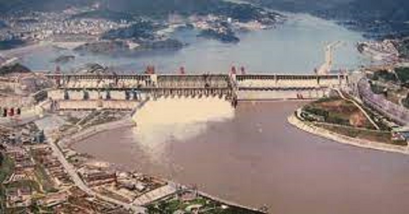
China is believed to have the most dams, with some estimates putting its number at close to half of the world’s 50,000 large dams. In China, some dams are bigger than ‘large’, and they are so large that they can only be described as mega dams. Consider the Three Gorges Dam, the world’s largest hydroelectric dam with a generating capacity of 22,500 megawatts, built by China on the Yangtse River. It was commissioned just days before the 100th anniversary of the Chinese communist party in 2021, making it the world’s second-largest hydroelectric dam. The Baihetan Dam on the Jinsha River, a tributary of the Yangtze, is also said to be the world’s biggest arch dam.
Now, there are talks of China building another super dam, bigger than anything else in existence, on the Yarlung Tsangpo that becomes the River Brahmaputra in India. In the Medog region, where the Yarlung Tsangpo takes a U-turn and begins its descent into India, this dam will be built. China’s 14th five-year plan calls for a dam three times more powerful than the Three Gorges Dam. India is more concerned with the nature of the dam and the river it will be built upon – the Yarlung Tsangpo/Brahmaputra than the power it will generate.
The Yamuna begins in China near Mount Kailash, then crosses into India as the Siang, then the Brahmaputra, before joining with the Teesta and entering Bangladesh as the Yamuna, where it meets the Ganges at Goalando. South-eastern Tibet is where China plans to build the largest dam the world has ever seen, where the river bends sharply and rushes through one of the world’s most dramatic gorges. The Yarlung Tsangpo gorge stretches over 500 kilometers and is carved from granitic bedrock that reaches 17,000 feet above sea level in some places, making it three times as deep as the Grand Canyon.
There are concerns in India and Bangladesh about how much of the water of the Brahmaputra and Yamuna will be blocked by the massive dam that China plans to build in this Yarlung Tsangpo canyon. There are some experts who think this may not be so worrisome since the Yarlung is situated in the rain-shadow zone north of the Himalayas and receives much less precipitation than its south course.
In Tibet, the river receives about 300mm of rainfall on average each year because of snowmelt and meager rainfall when it rains. After the U-bend, as the river moves towards the foothills and into India, the average annual precipitation, mainly rain, is 3,000 mm or more. Between where it comes out of the canyon and halfway down the Brahmaputra valley in Assam, the river flow increases by about 10 times. There are also at least seven very healthy tributaries of the Brahmaputra that contribute to its massive flow.
China’s damming of Yarlung Tsangpo would not have a great impact on Brahmaputra’s flow of water, and it is unlikely that the Chinese dam would have an impact on India or Bangladesh’s economies. In reality, the real concern lies in the future dam’s environmental impact and the possibility of an accidental breach.
Read more: Despite divorce rumours, Naga Chaitanya& Samantha welcome a cute new addition to the family
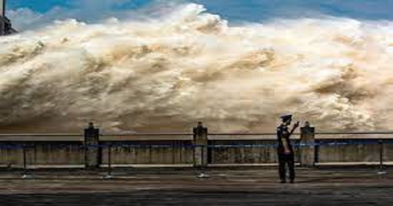
Medog region experiences heavy monsoons, landslides, avalanches, and flash floods are common occurrences. Add to that the suspect tectonicity of the Eastern Himalayas, meaning earthquakes are not uncommon in the region. Consider what could happen if a mega dam built here bursts due to an earthquake; the devastation that would cause in Arunachal Pradesh, Assam, and even Bangladesh with a wall of water, like a tsunami, sweeping everything in its path.
Approximately 230,000 people died when the Banqiao Dam, located in China, collapsed in 1975. A dam had burst following incessant rains, causing a wall of water nearly 20 feet high and 11 kilometers wide to surge downstream, bursting 62 other dams downstream, killing 26,000 people within a few hours. Certainly, there is no comparison between the near primitive engineering of the Banqiao and what China is capable of today, but that won’t stop people living downstream from becoming concerned. A mega dam can never guarantee a failsafe against nature, and there will always be the danger of a mega disaster if several earthquakes or landslides occur in the region.
Post Your Comments