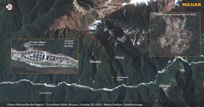
Five years after Indian and Chinese troops clashed on the Doklam plateau, which is surrounded by India, China, and Bhutan, new satellite images have emerged, indicating a Chinese village built nine kilometres east of the region on the Bhutanese side, according to local media reports. In 2017, Chinese and Indian armed forces were locked in a 73-day standoff at the Doklam trijunction after China attempted to extend a road through territory claimed by Bhutan.
According to NDTV, which has access to Maxaar’s satellite images, the village has been named Pangda and is currently populated by cars parked on the doorsteps of nearly every home. A neatly marked all-weather carriageway near the village is part of China’s ‘extensive land grab’ in Bhutan, according to the report. According to the NDTV report, new satellite images show that a second village in the Amo Chu river valley is nearly complete, while China has accelerated the construction of a third village or habitation further south.
The new report comes as the People’s Liberation Army (PLA) has repeatedly expressed concern about increased construction activity along the India-China border at the Line of Actual Control in eastern Ladakh, where the Chinese People’s Liberation Army (PLA) has been engaged in a two-year standoff with the Indian Army.
In terms of security, India regards the Doklam tri-junction as an important strategic route. New Delhi had objected to the tri-junction road construction because it would have jeopardized its interests. The 2017 confrontation even sparked fears of a nuclear war between the two nuclear-armed neighbours. Bhutan claimed ownership of the area, which India supported. The India-China face-off was resolved following several rounds of talks.
Post Your Comments