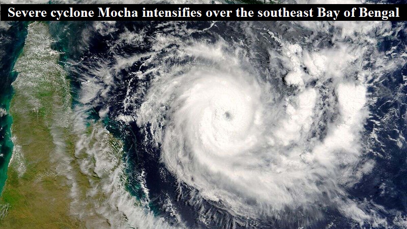
On Friday morning, the severe cyclone Mocha intensified over the southeast Bay of Bengal with winds reaching 140-150 km/h and a gust of 165 km/h. India Meteorological Department’s Director General, M Mohapatra, explained that dry, continental winds are blowing over all of east India towards Cyclone Mocha. Mohapatra predicted severe winds and rain for the northeastern states on May 13 and 14.
Mocha has now become a “very severe” cyclonic storm over the southeast and adjoining areas of the central Bay of Bengal. IMD reported, “The SCS “Mocha” intensified into a very severe cyclonic storm, lay centered at 05:30 hours IST of 12th May 2023 over central adjoining southeast Bay of Bengal near latitude 13.2N and long 88.1E, about 520 km west-northwest of Port Blair.” The IMD has issued warnings for potential landslides in sensitive areas, minor damage to weak or unstable structures, uprooting of small trees and breaking of tree limbs, and damage to tiny trees such as banana trees in Mizoram, Tripura, and South Manipur.
The IMD has requested farmers to quickly harvest mature fruits and crops, stake and cover vegetable nurseries and orchards, refrain from using chemicals, and confine cattle to sheds. The rough to phenomenal sea with wave heights of 9-14 meters is expected to impact the shipping and offshore industries until Saturday. IMD has advised regulating shipping, offshore operations, and tourism around the Andaman and Nicobar Islands. It has also suggested limiting ships until Sunday in the Bay of Bengal and the Andaman Sea.
Mohapatra assured that Mocha is unlikely to impact the monsoon, which usually arrives in Kerala around June 1. He explained, “Mocha is a transient system, and there is still a fortnight left for the normal onset date for monsoon. We do not think the very severe cyclone will impact monsoon onset.” On Friday morning, Mocha was around 520 kilometers to the west-northwest of Port Blair. An IMD official reported that the tropical heat potential, which fuels the cyclone, is at its highest level near the coast of Myanmar.
According to climate scientist Roxy Mathew Koll of the Indian Institute of Tropical Meteorology (Pune), the Bay of Bengal is significantly warm, with sea surface temperatures over 30°C over most parts of the ocean. Sea surface temperatures near Myanmar were as high as those around the Bay at 30-32°C, or 1-2°C above average. Koll added that “The subsurface conditions are also warm, but not as warm as central Bay.”
Mocha is likely to cause extreme heat in several areas of east and northeast India due to the winds and moisture it is attracting. On Wednesday, parts of Nagaland, Manipur, Mizoram, Tripura, and Gangetic West Bengal experienced maximum temperatures well above average (5.1°C or above). IMD has issued a heat wave warning for patches in Gujarat, Madhya Maharashtra, Bihar, and West Bengal on May 11, Konkan from May 10 to 12, Rajasthan on May 12 and 13, and coastal Andhra Pradesh and Yanam from May 13 to 15. Additionally, uncomfortable weather is predicted in the Konkan, Odisha, Kerala, and Tamil Nadu due to the humidity and high temperatures.
Post Your Comments